Fishing districts, map and water
Discoveries, nature and geology by the water: gold, rocks, hazards
- Reading
- 11 min
- Steps
- 4
- Image
- 7
- Updated
- 18 Nov 2026
Under and around the water there is a lot you cannot see at first glance: rocks that make the water hard, old mines, heat from deep underground, and wildlife and plants along the bank. The portal has linked this public data to every fishing district. In the Discoveries section you will find it as rankings and ideas for exploring, and on each fishing district page for that particular water.
Discoveries
Topics about water, fish and geology with fishing district rankings
The Discoveries page answers questions such as “which river has the most gold” or “where is the water best suited to trout”. Most topic cards show the number one in the ranking straight away. All topics are also in the Discoveries drop-down menu. At the bottom of the page is the Map of fishing districts by water suitability, where the colour of each line shows how well the water suits the fishing district type.
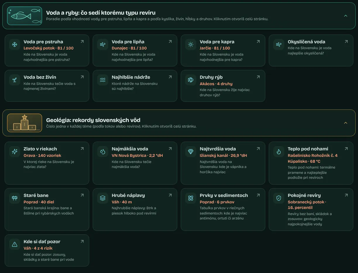
| Group | Topics |
|---|---|
| Water and fish | Water for trout, Water for grayling, Water for carp, Oxygenated water, Nutrient-poor water, Deepest reservoirs, Fish species |
| Geology: records of Slovak waters | Gold in rivers, Softest water, Hardest water, Heat underfoot, Old mines, Thick deposits, Elements in sediments, Quiet fishing districts, Where to be careful |
| By rock type and ready-made recipes | Rocks beneath the water, Fishing district recipes |
How to find fishing districts by topic in Discoveries4 steps
Open Discoveries
In the menu, tap Discoveries and then a topic, or open All discoveries.
Choose a topic
Tap a topic card, for example Gold in rivers or Water for trout.
Check the ranking
The Ranking of fishing districts and Ranking of streams sections show where the value is highest.
Open the map
The Where to find it on the map section has a map with the filter applied. You can narrow the filter by region or water type and click a fishing district to open it.
Topic page
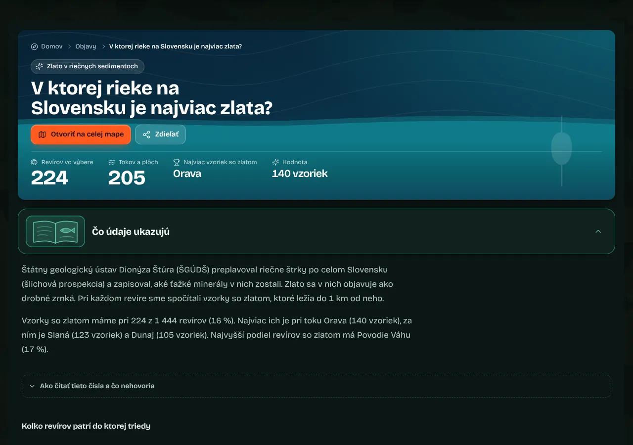
- What the data show
A short explanation and How many fishing districts belong to which class.
- Ranking of fishing districts and watercourses
Rankings showing the value for each fishing district or watercourse. Click one to open its page.
- Where to find it on the map
A fishing district map with the filter set to the topic. You can adjust the filter further. The Open on the full map button in the topic header opens the full fishing district map with the same filter.
- Try looking for
Ready-made filter combinations for the topic, with the number of fishing districts. Click one to open the map with that filter.
- River basins and regions
How the topic breaks down by river basin and region.
- On which rocks you will find it
For geological topics, the rocks it relates to.
- FAQ, more discoveries and sources
Answers to questions about the topic, links to other topics and Where the data come from and what they do not say.
Fishing district recipes
The Fishing district recipes page combines two to four data points (geology, oxygen, nutrients, depth, water suitability for the fishing district type) with water type and location, and shows the fishing districts where everything matches. At the top is the Recipe of the week with a map, and each recipe shows how many fishing districts match it. Click a recipe to open the map with the filter already set. Recipes are grouped into For trout anglers, For carp anglers, For the curious and For a family trip. A recipe with no matching fishing districts is not shown on the page.

Nature and hazards at the water
Wildlife, birds, plants and what to watch out for at a fishing district
On the fishing district page, expand the section Nature and hazards at the water. The Wildlife, plants and hazards around the water block shows species that people have recorded around the water (GBIF database, an area of roughly 35 × 55 km around the water). If the fishing district extends into a protected area, the section header shows its level of nature protection.

Risks
Bear, wolf, wild boar, adder, ticks, mosquitoes, horseflies and giant hogweed. Each has a higher risk or to be reckoned with label; for a higher risk, the How to protect yourself advice is already open.
Wildlife and birds
Animals and birds recorded around the water, with a protected species or invasive species label and a short description under About the species.
Plants
Plants on the bank and in the water, including invasive ones.
Records by month
A small bar chart for each species shows the months in which it is observed most often (for example Most records: June.), with the current month highlighted. The many records, quite a few records, a few records or a single record label refers to the number of observations, not to how many animals live there.
Species catalogues
The species name links to its page. Below the tiles are the Fish catalogue with all species and Animal and plant catalogue buttons.
Protected areas and invasive species
Where nature protection applies and what must not be spread
- Nature protection on the fishing district page
In the About the fishing district section, the Location, area and nature protection card has a Nature conservation row showing the protection level of the area the fishing district extends into. The same information appears in the header of the Nature and hazards at the water section.
- The Protected area label
A fishing district card (for example in the Other fishing districts nearby section) has a Protected area label when the fishing district extends into a protected area.
- Invasive fish species
The fish catalogue has an Invasive fish species section and an Invasive filter. Each species page shows its classification under the decree.
- Invasive animals and plants
The animal and plant catalogue has an Invasive species by the water section and an Invasive filter.
- Invasive species around the fishing district
The Invasive species nearby (GBIF) factor in the water quality summary on the fishing district page lists non-native fish, animals, crayfish, mussels and plants that have turned up around the water. An occurrence does not mean that the species lives in this particular fishing district.
Geology and geophysics at the fishing district
Rocks under the water, faults and springs, radon, magnetic field, earthquakes
The fishing district page has a section called Geology and geophysics. The main block, Ground under the water: geology, faults and radon, has an interactive bedrock map with cards below it. This is information about the environment; only small hypotheses, labelled with a level of certainty, count towards the conditions score.
Bedrock map
- Loading the map
The map loads when you scroll down to it on the page (or use the Load map button). You can pan and zoom it.
- Whole fishing district and Whole watercourse
Buttons zoom the map to the fishing district or to the whole watercourse. For a fishing district without an exact location, there is a Surroundings of the point button.
- Map base layer
Geology (rocks from the 1:50,000 geological map), bedrock Radon risk, Uranium (eU) and Gamma radiation from airborne gamma-ray spectrometry, and Magnetics (magnetic field anomalies). Each base layer has a description, a legend and a For anglers paragraph.
- Base map transparency
The slider makes the base layer stronger or fainter.
- Value at a spot
Click or tap the map to see the base layer value at that spot.
Cards below the map
Values at the water spot
Bedrock radon risk, uranium, thorium, potassium, gamma radiation and the magnetic anomaly at the fishing district, with a short explanation.
Faults and springs
Distance to the nearest tectonic fault and the number of springs within 1 km. Fissure water emerges along faults; it tends to be cooler in summer and warmer in winter.
Rocks and water chemistry
The predominant rock group where the water is (for example alluvium, limestone and dolomite, flysch, granite) and what this usually means for the water's hardness, pH and productivity.
Geomagnetic activity (Kp)
The Kp index (0 to 9) over the last 48 hours and a forecast for the next 24 hours. From 5 upwards, it is a geomagnetic storm (G1 to G5). The value is the same for the whole of Slovakia; only a geomagnetic storm (Kp 5 or higher) counts towards the score, as a hypothesis: −1 point, and from Kp 7 −2 points.
Earthquakes nearby
Tremors within 150 km over the last few days, from the GFZ GEOFON catalogue. The period and minimum magnitude are stated on the card (by default 30 days and magnitude 1.0 or above). They do not count towards the score.


- Bed and bedrock according to maps
The Where to fish section (for reservoirs, next to the 3D model) has a card showing what the bottom and banks are made of: rock, sediments and their effect on the water.
- Water chemistry and contaminated sites
Trace elements, sediments, landfills and contaminated sites in the area are covered in the Water quality and cleanliness section; see Water conditions and quality.
- Geology of the watercourse and river basin
Watercourse and river basin pages have seven geology sections (rocks, chemistry, gold and mines, heat and boreholes, radioactivity, contaminated sites and landslides); see River basins, watercourses and towns.
- Geophysics in the 3D model
The Geophysics mode in the 3D bed model shows the radiation and magnetic field of the rocks directly on the terrain; see 3D bed model.
- Geology in filters and sorting
The fishing district map has a Geology filter group, and the Sort fishing districts list has options based on ŠGÚDŠ data, for example hardest water, most samples with gold or fewest contaminated sites and landfills.
Wikidata and photos
River lengths, reservoirs, towns and photos from Wikimedia Commons
- Rivers
On a watercourse page, in the About the river section: the river's length from source to mouth (including outside Slovakia), catchment area, mean discharge at the mouth, where it flows into, and its rank by length among the rivers of Slovakia.
- Reservoirs
The area, volume, depth and year of construction of a reservoir, on the water body page and on the Reservoirs in 3D page.
- Towns
Population, altitude and area on the Where to fish page.
- Photos
Photos of rivers, reservoirs, towns, fish and animals come from Wikimedia Commons. The author and licence are shown below each one.

Frequently asked questions
6 questions with short answersQuestions6
Does a high ranking in Discoveries mean the water is cleaner or better for fishing?
No. The ranking shows a value from public atlases and models for the fishing district; it is not an assessment of water quality or a guarantee of a catch.
Am I allowed to pan for gold in a fishing district?
The portal does not assess this. Gold panning is subject to several regulations; check them with the watercourse administrator and the landowner.
Why is there no Nature and hazards section for a fishing district?
The section only appears when the GBIF database has records for the area around the water.
Does the radon risk on the map mean radon in the water?
No. The map shows the radon risk of the bedrock, based on the radioactivity of rocks and fissures; it is not a measurement of radon in the water.
Does a magnetic storm affect bites?
This has not been reliably proven. Only a geomagnetic storm (Kp 5 or higher) counts towards the score, as a hypothesis with a small weight.
Where do the river lengths and photos come from?
From Wikidata (CC0 licence) and Wikimedia Commons; the author and licence are always shown below each photo.
No question was found for this search.
Related guides
Where to go next once you have read this
- Fish, rules and natureThe fish catalogue with a page for every species, what the law says today, the angler's year, animals and plants at the water, and guides.10 min · 4 steps · 8 screenshots
- Water now and water qualityWater level and temperature from SHMÚ, clarity and ice from satellite data, the quality index, pollution, treatment plants and groundwater near the fishing district.15 min · 9 steps · 10 screenshots
- River basins, watercourses and townsRiver basins and watercourses, the river page, where to fish in a town, fishing districts by region and district, SRZ organisations and fishing district rankings.13 min · 8 steps · 9 screenshots
- Fishing district mapFinding a fishing district, detailed filters, line colour and the legend, the Near me location, fishing district details on the map, layers at the fishing district and a link with your selection.19 min · 14 steps · 10 screenshots
More guides: Fishing districts, map and water
Fishing district map, fishing district page, fishing conditions, 3D bed, water, watercourses, towns and fish
- Fishing district pageThe header and four indexes, widgets from conditions to geology, searching the page, organisation notices, navigation and sharing.17 min · 13 steps · 14 screenshots
- Fishing conditionsThe Bites today score and what goes into it, the best window of the day, solunar periods, weather, sun and moon, close season and today's fishing hours.15 min · 5 steps · 9 screenshots
- 3D bed and river modelRotating the model with a mouse or finger, lowering the water level, the depth at a spot, layers, fishing spots by fish species and the accuracy of the model.20 min · 13 steps · 10 screenshots