District
Fishing districts – Žiar nad Hronom district
- Fishing districts
- 9
- Total
- 120km
- Watercourses and water bodies
- 8
- SRZ organizations
- 2
Žiar nad Hronom district at a glance
Overview of fishing districts in Žiar nad Hronom district (Banská Bystrica Region): 9 fishing districts on 8 watercourses and water bodies, about 120 km in total.
The longest are Hron (21 km), Lutilský potok (20 km), Kremnický potok (19 km).
By water type: salmonid (trout) (6), carp (3).
Today: Žiar nad Hronom district
Is it worth going today? Average fishing conditions score, the best window of the day and the best fishing districtsConditions score51 / 100Best window15:00
District average
Average activity · average of 9 fishing districts
- Very high0
- High2
- Average6
- Low1
When the best window ishow many fishing districts have their best two-hour window in a given hour
Most fishing districts have their best window around 15:00.
Best conditions todayfirst 6 of 9 fishing districts
- Ihráčsky potokSalmonid (trout) · 16 km · Ihráčsky potok61
- Vyhniansky potokSalmonid (trout) · 14 km · Vyhniansky potok60
- TepláSalmonid (trout) · 16 km · Teplá59
- Prochotský potokSalmonid (trout) · 14 km · Prochotský potok58
- Kremnický potokSalmonid (trout) · 19 km · Kremnický potok55
- Lutilský potokSalmonid (trout) · 20 km · Lutilský potok54
The score is an estimate of conditions based on weather, water and surroundings, not a bite forecast. Recalculated at 16:23.
Map and fishing districts: Žiar nad Hronom district
Where to fish? A map and a list of fishing districts starting with the best conditions. You can switch the line color to today's conditions, quality or any other parameter.Fishing districts9Length120 km
Detailed filtersregion, district, riverbed, depth, shading, satellites, water chemistry and pollution, fish, geology
Move the map with two fingers. In full-screen mode one finger is enough.
The score is an estimate of conditions based on weather, water and surroundings, not a bite forecast. For each fishing district you can see what it is made of, how well it is supported by data and where the data comes from.
Rivers, streams and water bodies: Žiar nad Hronom district
Which waters are best today? Ranking by conditions, length of fishing districts and the best fishing district of each waterWatercourses8
Watercourses and water bodiesfrom the best conditions today, without a score by fishing district length
- Ihráčsky potok1 fishing district · 16 km61
- Vyhniansky potok1 fishing district · 14 km60
- Teplá1 fishing district · 16 km59
- Prochotský potok1 fishing district · 14 km58
- Kremnický potok1 fishing district · 19 km55
- Lutilský potok1 fishing district · 20 km54
- Hron2 fishing districts · 21 km41Hron č. 6b44
- VN Zákruty1 fishing district · 0.6 km32
SRZ organizations: Žiar nad Hronom district
Who manages the fishing districts here? Organizations with their number of fishing districts and today's conditionsOrganizations2
Local SRZ organizationsorganizations that manage fishing districts here
- Žarnovica3 fishing districts · 44 km59Vyhniansky potok60
- Žiar nad Hronom6 fishing districts · 76 km47Ihráčsky potok61
Fish and catches: Žiar nad Hronom district
Which fish live here and what has been caught? Game species recorded in the fishing districts and approved catches by anglersGame species4
Game species recorded in the fishing districts


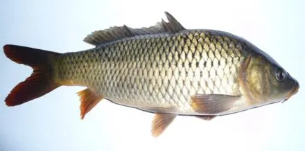

The number next to a species is the number of fishing districts where it is recorded by a catch, a stocking plan or an observation at the water.
Water pollution: Žiar nad Hronom district
Water quality according to SHMÚ, wastewater treatment plants near the fishing districts and groundwater nearbyFishing districts failing a standard6 / 6
Surface water near the fishing districtsnearest SHMÚ monitoring site, 2025
6 of 6 fishing districts with SHMÚ data in the district have an unmet standard at the nearest site in at least one indicator.
- 1 to 2 indicators5
- 3 or more indicators1
- No SHMÚ data3
Most polluted fishing districtsall with an unmet standard
- Kremnický potokKremnický potok · standard not met in 3 of 4 years8 indicators
- Hron č. 6aHron · standard not met in 4 of 4 years1 indicator
- Hron č. 6bHron · standard not met in 4 of 4 years1 indicator
- Lutilský potokLutilský potok · standard not met in 2 of 4 years1 indicator
- Prochotský potokProchotský potok · standard not met in 1 of 4 years1 indicator
- VN ZákrutyVN Zákruty · standard not met in 1 of 4 years1 indicator
Groundwater: measured valuestypical value from stations within 10 km, 2025
9 of 9 fishing districts with measurements have groundwater nearby with a value above the limit for at least one indicator.
- harmful substances above the standard at at least one station (metals, pesticides, PFAS, solvents)9
- iron from 1 mg/l3
Water pollution in the Hron basinPolluted water in Slovakia
Source: SHMÚ (yearbooks on surface and groundwater quality), the register of wastewater treatment plants from VÚVH and the EEA. A SHMÚ site is assigned to a fishing district by the same watercourse name and by distance; the yearbook lists the sites that failed the standard, so a missing site is not proof of clean water.
More locations and towns
Where next? Neighbouring districts and regions and the “Where to go fishing” pages of district townsLocations13
Region and neighboring districts
- Banská Bystrica Region
- Banská Bystrica district
- Banská Štiavnica district
- Brezno district
- Detva district
- Krupina district
- Lučenec district
- Poltár district
- Revúca district
- Rimavská Sobota district
- Veľký Krtíš district
- Zvolen district
- Žarnovica district